- HubPages»
- Education and Science»
- Life Sciences»
- Paleontology
The Loch Ness Monster and Google Earth

The Loch Ness Monster
Loch Ness is the second largest of the Scottish Lochs and stretches 23 miles long. It is the deepest of all the Scottish lochs and contains more fresh water than all the lakes in England and Wales put together.
Situated as it is in one of the most scenic parts of the British Isles it is a very popular destination for tourists visiting Scotland. The Loch is all the more popular with visitors because they may spot 'Nessie', the Loch Ness Monster. Believer or sceptic everyone will cast their eyes across the water.
Fiction mixes with fact and over the years I have come across woodcut prints that suggest the 'monster' was known hundreds of years ago. This does not seem to be the case when one examines the documentary evidence. The first written up record is dated 1871. There have been numerous water and land based sightings since then. Some have even been photographed and equally some discovered to be hoaxes.
You can learn much more about the Loch Ness Monster and its history from the following links:
loch ness monster Scottish Legend
The Monster from Google Earth
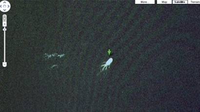
Google Earth and the Loch Ness Monster
Spotted on land, spotted in the water. It was only a matter of time before somebody would report seeing the Loch Ness Monster from the air. I don't think anyone would have dreamed that it would have been via Google Earth though.
This monster, this 'Nessie' looks somewhat different to the others, in fact it looks more like a Giant Squid. Whatever, this new sighting is going to rejuvenate the hunts and the tourist trade too.


